Blog #17: “The 20 Most Beautiful Small Towns in the World”
A few weeks ago, I saw an article published by Condé Nast Traveler (November, 2025). It was titled “The 50 Most Beautiful Small Towns in the World”. After glancing at the article, I decided that I could surely come up with a list that is as compelling. Making such a list is very, very subjective. After a couple weeks, I decided to write this blog and not look at what was in Condé Nast Traveler. I put my title in quotes, because the list could easily have been 20 other towns. When I concluded my list of 20, I went back to look at the CNT list of 50 and found that I have been to 27 of them, and I have visited near four others on their list. Despite my familiarity with most of their towns, I find that I included only five that they have, but most on my list are not on theirs and I have left most of theirs that I have visited off my smaller list. For no particular reason, the blurb picture is of some houses along the riverfront in Bamberg, Germany.
Here are some small towns in the world that are definitely worth a visit. They are not listed in any particular order.
Dinan, France. The people of France have several charming small towns that have been well-maintained over centuries. I will pick Dinan, Brittany, to show some pictures, but I must mention a couple others elsewhere in France that are certainly worthy of a visit: Collonges-la-Rouge and nearby Turenne in Nouvelles-Aquitaine, Pérouges near Lyon, Colmar (and Riquewihr and Equisheim and Kaysersberg) in the Alsace, beautiful Annecy situated beautifully with lake and mountains a little south of Geneva, Yvoire also near Geneva, Périgueux, Sarlat and Cahors in the Dordogne, Vannes in Brittany, Bonifacio in Corsica. Oh, I must stop someplace as there are just too many to list all.
Walking through Dinan is really a pleasure with its many half-timbered houses, cobbled streets, old city walls, castle/château, gardens, and river flowing through. Some of the buildings date back to the 13th century. In addition to the houses, the old churches and ramparts give a distinct feel to the medieval city, which undoubtedly inspire the locals in their medieval costumes as they celebrate their biannual festival in July (which I have not personally seen). Walking down Rue du Jerzual, out the old gate to the port, and then along the River Rance is a good idea. There are many tempting
Dinan, France, port area on the River Rance viewed from the Tower of St. Catherine. (2021)
Dinan, Brittany (Bretagne), France, is a wonderful, well-preserved town for a stroll.
Looking down Rue du Jerzual in Dinan. (2021)
restaurants in the center of town as well as the port where one can enjoy one of several dishes made with one of the staples of Brittany cuisine, buckwheat crêpes.
Khiva, Uzbekistan. In Australia, some towns earn the title “Tidy Town“. If that was done in Uzbekistan, Khiva, in particular its World Heritage-listed, walled old city of Itchan Kala (Ichan Qal’a) would surely qualify. Along with the larger, but wonderful, Uzbek cities of Bukhara and Samarkand, Khiva was an important trading point along perhaps the most important of the Silk Roads. Khiva also served as the capital of the Khiva Khanate from about 1500-1900, finally succumbing to the Russians in the 19th century as Russia and Britain competed for dominance in Asia. Formally, the Khanate existed into the early 20th century, but it was under the control of the Russians. These days,
Entrance to Konya Ark, the fortress, from inside the old city of Khiva, Itchan Kala. (2025)
Khiva has a very relaxing vibe, especially in the evening with local children playing in the open spaces within Itchan Kala. While Khiva is certainly visited by tourists, the majority are gone from the plazas and streets in the evening and night. While there are places of interest to visitors outside Itchan Kala, the majority of sites are easily walkable within the old city walls (or on the old city walls). Like Bukhara and Samarkand, Khiva has several tile-covered palaces, fortresses, madrasas (madrassa, madrasah), mausoleums, and souks, but it is considerably smaller and therefore more easily walked. It is worthwhile to go up on the western wall of Itchan Kala for a nice view as the sun sets. It is possible to walk part of the way along the wall.
In Khiva, a tower of the Mohamed Amin Khan Madrasa (left) and the Kalta Minor (right), an unfinished minaret. The bronze statue at the base depicts the ideal that two gentlemen in retirement should be able to relax, drink tea, and laugh. (2025)
Entrance to the Muhammed Rahim Khan Madrasa in Khiva. The madrasa was built in 1871, commissioned by the last Khan of Khiva for whom it is named. (2025)
View up to the “New Bridge”, Puente Nuevo, built in 18th century and spanning two parts of Ronda, Spain. (2023)
Ronda, Spain. Perhaps the most visually striking thing about Ronda is the 120-meter high Puente Nuevo spanning the two plateaus comprising different parts of the town. This “New Bridge” was built in the period 1751-1793 and is so named to distinguish it from the old bridge, Puente Viejo. The views to the west or down on the Rio Guadalevín flowing beneath are delightful on a walk across the bridge and continuing the walk along the west side by the cliffs of either the northern or southern mesas. The cliffs apparently served to execute Nationalists early in the Spanish Civil War by tossing them off, as they were used at earlier historic times.
Pedro Ramón Restaurante, across the street from the Plaza de Toros de Ronda.
The mountainous area of Ronda largely owed its past popularity to providing relief from the summer heat of the coast. And it proved to be an attractive place to dwell for writers such as Ernest Hemingway, Washington Irving, and Rainer Maria Rilke. Ronda still has bullfights in its Plaza de Toros, built in 1784. Across the street is the Pedro Ramón Restaurante, which is very popular with the bull-fighting crowd as attested by the many signed pictures on the walls.
Ronda’s Puente Nuevo at night. (2023)
The Old City Hall of Bamberg on an island in the Regnitz River. World Heritage-listed Bamberg is at the extreme northwest of the beautiful Fränkische Schweiz region. (2006)
Bamberg – Tüchersfeld – Pottenstein – Gößweinstein, Germany. Well, Tüchersfeld is so small that it rightfully should be called a village, and nearby Pottenstein is not too large either. In fact, administratively they are combined. These four places I list are just part of the beautiful area known as the Fränkische Schweiz (or Franconian Switzerland in English) in upper Bavaria. It is a wonderful area for scenery, hiking and caving. Around the world, if a place is beautiful and has mountains, rocks, and maybe lakes, it is called XX Switzerland. In the 18th and 19th centuries, it was popular to name such areas after Switzerland. Do you know of a beautiful city or town with canals that is not somehow called “Venice”? Maybe Amsterdam?
It is difficult to pick just one town in the area, so I’ll just put them all in here. In this way, if you go see them all, you must see the beautiful area between the towns. I have visited the area three times and always find it to be a joy.
Charming Tüchersfeld is located in Püttlachtal (the Püttlach Valley). The valley is great for scenery, hiking, biking and rock climbing. (2006)
World Heritage-listed Bamberg essentially defines the northwest boundary of the Frankische Schweiz. It lies on both banks of the Regnitz River just upstream of its confluence with the Main River. Much, but not all, of the medieval old city is on an island as the Regnitz splits into two branches that rejoin shortly. There are hundreds of medieval buildings and cobbled streets as well as multiple foot bridges across the river to lend a pleasant ambience to the town.
Tüchersfeld lies in the gorgeous Püttlach Valley approximately 25 km SW of Bayreuth, which largely defines the eastern limit of the Frankische Schweiz and is a terrific place to visit as well (but is too big to fit my criterion of “small town”). Also partially in Püttlach Valley is Pottenstein. Both places have old half-timbered houses with numerous karsts giving an other-worldly silhouette to the horizon. Views from below are delightful for photography, but there are numerous places one can climb, including up the odd-shaped rocks, that give a terrific view as well. Tüchersfeld has the museum for the Frankische Schweiz. It is housed in a group of buildings, synagogue included, built by several Jewish families in the 17th and 18th centuries. In Pottenstein, one can visit the Pottenstein Castle high on a rocky prominence.
Gössweinstein with basilica and, in the distance, the castle in view. (2005)
Goßweinstein lies a few km to the west of Püttlachtal, and it also has some magical hiking trails amidst the fantastic rocks, hills and valleys in the vicinity. The town of Goßweinstein itself also has a castle perched on high as well as a basilica with a fine baroque interior more grandiose than one would expect from the size of the town.
Salento and the other small towns of the Zona Cafetera, the coffee-growing region of Colombia, exhibit a distinct architectural style developed by the founders in the 19th century. The first week of January has a fiesta celebrating coffee. (2019)
The palmas de cera (wax palms) are not the only attractive feature of the beautiful Valle de Cocora, only 30-minutes drive from Salento. It has excellent bird-watching along its streams and verdant hills. (2019)
Female quetzal in the Valle de Cocora. This is only the second wild quetzal I’ve seen in my life. The first was a male flying in the Monte Verde, Costa Rica, cloud forest, but I couldn’t get a photo. (2019)
Salento, Colombia. Colombia has numerous places vying to be on a list of most beautiful towns. However, I will choose to highlight Salento, as it lies in the verdant Zona Cafetera, the coffee-growing region, along with the nearby picturesque town of Filandia. Both of these towns feature an architectural style characteristic of the region. Salento is the closest town to the unique Valle de Cocora, a jaw-dropping gorgeous area, with the world’s tallest palm tree, 60-meter high palma de cera (wax palm). The center of Salento is on the UNESCO World Heritage list. Naturally, coffee shops featuring the local arabica coffee are in abundance, but so are other local craft shops and restaurants; meandering around town is quite enjoyable. I highly recommend spending a full day to enjoy a hike in Valle de Cocora, although a half-day is possible. While you can stay in Valle de Cocora (we did), Salento gives more options for a 30-minute drive. There are several fincas (coffee farms) in the area that give tours.
Luang Prabang, Laos, has several Buddhist temples. The oldest and most important is Wat Xieng Thong, whose central shrine hall is shown here. (2018)
Luang Prabang, Laos. Luang Prabang is a delightful place to hang-out or to take off on excursions. It is located at the confluence of the Nam Khan and Mekong River. With its distinct Laotian architecture, a few dozen Buddhist temples, and natural setting, the area has been put on the World Heritage list. Activities abound as well: hiking, biking, cruising by boat, e.g., kayak, on the rivers, learning to cook local food. You can also get up before dawn and witness the alms-giving ritual of local Buddhists and Laotian pilgrims lined up near the monasteries to give food (rice ± snack) to saffron-garbed monks who exhibit their humility by filing past with their receiving bowls, thus enabling givers to attain spiritual credit. This is a quiet, respectful ceremony that has rules for participants; nonparticipants should be as discreet and unobtrusive as feasible, i.e., no noise, no flash, and no getting in the way.

Buddhist monks receiving alms, chiefly offerings of rice, at dawn in Luang Prabang. (2018)
Luang Prabang is the kind of place you visit and then think you would like to spend just a few more days no matter how long you’ve stayed. Sure, there are great things to see and do, but the ambience pulls on you to remain. While there is an abundance of temples, the Wat Xieng Thong monastery complex in the middle of Luang Prabang is the oldest and arguably the most striking.
View down the Nam Khan from Nong Khiaw in the direction of Luang Prabang. (2018)
There are several good day or half-day trips in addition to the activities I cited above. The rivers provide a means of transport to some of them, such as the Pak Ou Caves with a myriad of Buddhist images, waterfalls, and villages famous for rice whiskey manufacture, weaving, and exhibitions of strange artifacts.
My wife and I went for a few days up the Nam Khan with interesting sights along the way to Nong Khiaw and then hired a boatman to take us up the Nam Ou (Ou River) to Muang Ngoi. We glided past water buffalo, fishermen, people in dugouts, and kids playing in the slower water at the side of the river. We hiked in that area, finding the experience and the people to be fascinating and the landscape to be beautiful.
Eiger, Mönch and Jungfrau (left to right). Photo taken from the north side of Mürren. (2004)
Mürren, Switzerland. Switzerland has numerous towns that could easily fall into someone’s list of “top 20 towns in the world”. Picking just one, since there are other fantastic towns in the near vicinity, I’ll choose Mürren. It lies in the part of Switzerland that probably epitomizes what people who have never been to Switzerland think of when they think of the country – the Berner Oberland or Bernese Alps.
We must have an alphorn! We’re in the Alps! While hiking near Grindelwald, i.e., in the valley below Mürren, I came across this guy playing at his home. (2004)
There are no cars in Mürren, so we have gone there via a cable car lift from Lauterbrunnen up to Grütschalp and a stunning traverse hike over to Mürren, although the vast majority of people usually took the narrow-gauge train from Grütschalp to Mürren. Recently, the world’s steepest cable car was opened to take you directly from the valley floor up to Mürren. That’s probably a good way to get there, but I thought the hike across from Grütschalp was fabulous.
In the winter, skiing and sledding are very popular for visitors and locals, but I have only been in this area in spring and summer. Hiking, climbing, and basking in the scenery are highlights for nonwinter activities. As there are some celebrity-attracting hotels, I hear they have activities for those not wishing to wander too far away: spa, tennis, etc. Naturally, there is shopping too and some good places to enjoy dinner or lunch al fresco.
Trümmelbach Falls.A single photo or even a single video cannot begin to convey the drama of walking down the staircase winding beside these intracavern falls. The roar of the falls seems amplified inside the cavern, and you can feel the vibrations and water spray. This picture shows less than 10% of the falls. (2019)
Since this is in the Alps, of course, there are several picturesque waterfalls in the vicinity. You can hardly miss the striking waterfalls at Lauterbrunnen itself, since you drive through there. However, most people miss perhaps the most impressive of all, Trümmelbach Falls (aka Trimmelbach Falls), which is a little further up the valley past Lauterbrunnen. They are essentially across the narrow valley from Mürren. Despite the huge volume of water, you really cannot see them from Mürren! The falls are comprised of a series of ten drops in a long vertical cave inside a mountain lighted by occasional openings to the outside and by artificial lights. Access is via an elevator and stairs that zigzag around the falls. A friend who made his first visit to Switzerland with us said it was the most impressive thing he saw in the whole country.
In Telč, these 16th century houses are on the main square, Námėstí Zachariáše z Hradece (Zacharias of Hradec Square). (2007)
Telč, Czechia. In Blog #14, I urged people to visit some of the small towns and palaces of Czechia. It is easy to argue that Telč, Třeboň or Český Krumlov should be on a list of the top towns in the world. It is truly a pleasant experience to spend a few days there. I included several pictures of those beautiful and interesting towns in Blog #14, but I can’t resist putting one more here.
Bagan (Pagan), Myanmar. This is a “town” like none other. Yes, there is a town in which you can stay and eat, as the local people do, but Bagan really consists of the whole surrounding aggregation of more than 2000 surviving Buddhist temples, pagodas and stupas from more than 10,000 of them that were built in the 11th-13th centuries. Some of the temples purportedly contain relics of the Buddha. The Old Burmese pronunciation for Bagan was Pagan as it was spelled in the Latin alphabet until late 20th century. I visited in 1984 just when the country opened to foreigners not in a government tour group, for a maximum of seven days. Now there are much
A few of the ~2200 temples, pagodas and stupas in Bagan. In the background is the golden Shwezigon Pagoda and the Irrawaddy River behind that. (1984)
I rented a dilapidated bicycle to travel around on dirt roads, but it is certainly easier now. Bagan is on the World Heritage list. Money allocated from being listed by UNESCO enabled Myanmar to fix some of the decaying ruins and helped persuade the government to encourage tourism and thus improve the economy.
Shwezigon Pagoda in Bagan, Myanmar, near sunset. (1984) With money from UNESCO, the pagoda is much more golden now.
higher quality tourist accommodations, paved roads, and a museum, but the essential qualities of Bagan remain the same. There is now also a tower one can climb to get a view of the surrounding countryside with myriad temples, stupas and pagodas in all directions; however, it has always been possible to climb a few of the pagodas and get a good bird’s-eye view.
A vendor taking a break at the market in Nyaung-U, adjacent to Bagan. (1984)
Peacham, Vermont, USA. The United States does have several small towns with charm. I’ve been in some, but I find that in many of those I did not take any photos or it was long ago and I had a camera that yielded poor quality slides (especially after many years storage). Fall colors enhance the qualities of many places in the U.S. Perhaps not the first choice of most people, but I’ll choose Peacham as my representative for a couple different week-long trips to New England in the fall that were delightful. Frankly, the area is also quite pleasant in summer.
Covered bridge in Greenbank’s Hollow near Peacham, Vermont. In the mid-1800s, a large woolen factory was operating here based on a previous mill on the stream. It burned down in 1885 and was not rebuilt. (2012)
Peacham, Vermont, U.S.A. As in all of New England, in fall the trees are exploding with warm colors. The steepled church architecture is stereotypical of New England as well. (2012)
October day in the cemetery at Peacham, Vermont. Most of the gravestones date from the 19th century. (2012)
Just outside of Peacham is the covered bridge in Greenbank’s Hollow shown here, but there are many other old covered bridges within ten miles. There are numerous picturesque old bridges, mostly dating from the 19th century, in Vermont and New Hampshire. A couple covered bridges still standing were built for railroads.
Peacham’s town hall is a simple white clapboard building, characteristic of most older buildings in Vermont and New Hampshire. While it is also clapboard, the small general store in town is red, the same color as the many barns in the area. The town library is across the street. There are several houses that are built in that same distinctive New England style.
The cemetery is on the edge of town with rolling fields beyond the cemetery. The gravestones are generally modest, as one would expect in New England.
Lalibela, Ethiopia, has 13 churches hewn as monoliths from the rock mountain in the early 13th century. That pictured is Bet Giyorgis (Church of St. George). There is a priest inside the cross-shaped church, which is decorated with the mummified remains of a pilgrim, but it has fewer paintings and draperies than the older churches. Scale is difficult to discern in the photo, but it is 15 meters high including the carved base. (2024)
Lalibela, Ethiopia. Ethiopia is a double enigma. As the only African nation to resist European colonialism, until Italian Fascists partially occupied the land just prior to and early in World War II, it has a fascinating prehistory and history dating from the first hominids and humans that is not at all understood. Secondly, it is a beautiful country with a fascinating landscape and culture, including friendly people: so why has it been so thoroughly ignored by travelers? To the first point: there are academics who have tried to decipher the various pieces of evidence to develop a history of the nation. This may not necessarily be in accord with the history that every Ethiopian knows, the history that was given in the Kebra Negast. The Kebra Negast was written in the 14th century and tells the history based on a Solomonic origin. Most (all?) modern scholars do not consider it to be historically accurate, but Ethiopians are fully convinced of their origin story. There are enough other writings and historical events that touch on the story to give it a feel of “it should be true”.
Priest in Bet Methane Alem (Church of the Redeemer of the World) holding the original gold Lalibela Cross, weighing 7 kg and thought to be made in the 12th century. The cross is displayed only on special occasions. Bet Methane Alem is the largest rock-hewn monolith in the world; it has 36 pillars on the inside and 36 around the outside of the church. (2024)
Far predating that “history” of 3000 years, it is certainly well-established that the oldest known hominid skeleton of Ardipithicus ramidus from 4.2 million years ago and the best-preserved hominid skeleton of 3.2 million years ago, the Australopithecus afarensis called “Lucy” were found in Ethiopia; both are in the National Museum of Ethiopia in Adis Ababa. The oldest known skeleton from a Homo sapiens, 200,000 years old, is also from Ethiopia.
There are many interesting places in Ethiopia, but I’ll pick Lalibela as a terrific town to visit. Indeed, it is probably the most visited place in Ethiopia by the handful of tourists who come. Still, I visited most places in Lalibela, including the World Heritage-listed rock-cut monolithic churches, as the only tourist in sight. The UNESCO listing was for the 13 medieval churches and chapels carved entirely from rock, inside and out, beginning in the early 13th century possibly extending into the 14th century. I show a picture here of the last one sculpted from the rock. Ethiopians attribute all the buildings to King Gebre Meskel Lalibela who, with angelic assistance, single-handedly carved out all of them in a short period of time. There is wide discrepancy in scholars’ suggested bases for the creation of the rock churches with little to no evidence to support their conjectures. All 13 of them were cut below ground level in a rock mountain with most being interconnected by tunnels and trenches also cut into the rock.
In Lalibela, there are two types of historic dwellings – both round. Pictured is an example of the more elaborate two-story style with access to the top story being external to the building and highlighting pictorially the homemaking qualities of the woman of the house. (2024)
These churches are not relics of the past; there is daily religious activity with pilgrims and priests and music, with drums and chanting. And there are schools associated with the churches.
Lalibela has several houses characteristic of Lalibela; they are also part of the UNESCO heritage listing. I show a picture of one here. There are several of that two-story circular type, many with paintings on them. However, there are also many simpler one-story circular buildings made with dirt and sticks.
It was so enjoyable just to be in Lalibela, I cannot fail to point out that the mean temperature range is 21-25 ºC every month of the year. The hotel and restaurants I enjoyed are on a cliff edge with a fantastic view. Just pleasant to be there! I think I have to write a blog in the future focusing solely on Ethiopia.
Trinidad, Cuba. One of the most pleasant places on earth to spend a while is Cuba. Most people in the world are pleasant, but the Cubans are super friendly and helpful. This is especially amazing since life is difficult for them due to freedoms being restricted by the communist government and the consequent economic strictures imposed by the United States government that impoverishes the majority of the population.

Joyful music can be heard nearly every night at the Casa de la Música in Trinidad with dancing if it moves you. (2017)
One source of coping with the plight of the Cubans must be the joy that is expressed in music – all kinds from classical to heavy metal. However, the most widely heard music is endemic to Cuba. I am no expert, but I suspect Brazil is the only country in the world that has remotely as many endemic musical genres. Most of these have some aspects of African music mixed with elements from elsewhere, e.g., son cubano and cubatón, and always Cuban jazz. If you don’t listen to any of the various specialties, then surely you must have heard songs from the Buena Vista Social Club that have been played in popular venues in most of the world. That style can be heard every afternoon and evening in every modest-sized Cuban town, typically on the streets where 4-5 musicians gather always with a bass. People often do not simply listen – they dance. For so many different styles of music there must be as many different styles of dance. A good place an enjoyable evening in Trinidad is the Casa de la Música.
Old colonial mansions have been turned into fine restaurants in Trinidad, as elsewhere in Cuba. Pictured here from the Restaurant Paladar is one of the dining rooms clearly converted from a bedroom with the bed still intact. (2017)
As in many Latin American countries, 15-year-old Cuban girls celebrate their Quinceañera. The old Plaza Mayor in Trinidad here serves as a setting for the requisite photos of the celebration. (2017)
A tocororo (aka Cuban Trogan), Cuba’s national bird, was observed along with many other species while hiking Sendero Vega Grande, not far from Trinidad. (2027)
Trinidad has embraced its Spanish colonial heritage, preserving the old cathedrals, old mansions, and plazas. Fine views of the town and the area are had by climbing the tower of El Antiguo Convento de San Francisco de Asis. Besides the picturesque town itself, the region around Trinidad is beautiful; that includes agricultural fields but most especially Gran Parque Nacional Topes de Collantes with great hiking, swimming in aquamarine pools beneath waterfalls, and birding. Of course, a couple good beaches, e.g., Playa Ancon, are not far away.
As elsewhere in Cuba, entrepreneurs have converted mansions into interesting restaurants, principally for foreigners who can afford to pay for top quality dinners at a reasonable (for us) price.
Pitigliano, Italy, is at the southern edge of Tuscany just 2 km from Lazio. It has fascinating piazzas and narrow streets, some ending up at a cliff top. (2007)
Pitigliano, Italy. It is probably easier to list twenty small towns worthy of a visit in Italy than to narrow the choice to a single place. However, I will choose one, Pitigliano, that I’ve never seen anyone else highlight despite being as charming as others more celebrated. Furthermore, I will cheat in the same way that I did when trying to narrow my choice to a single place in Germany when I chose a few different towns in the beautiful Fränkische Schweiz area of Bavaria. Pitigliano is located in the extreme south of Tuscany 2 km from the border with Lazio. The neighboring towns of Pitigliano, Sorano and Sovana are within 2 km of one another.
Typical of many towns in Italy, Pitigliano is perched on a hilltop. The main piazza is attractive both to visitors and to locals sitting and sharing their lives or just enjoying the superb view. It is certainly worthwhile to wander the enchanting streets with delightful and sometimes amusing scenes encountered along the street or in the small piazzas.
Nearby, Sovana has a delightful main piazza with its its Palazzo Pretorio embellished with many coats of arms. The church Chiesa di Santa Maria Maggiore inside is interesting too, especially if you wonder about using bone relics as wall decorations. Just outside of Sovana on the NW side is perhaps the best Etruscan necropolis in existence, including that at Follonica. There are burial caves cut into the tufa rock dating back to the 7th century BCE, although the most impressive are a cluster built in the 3rd-2nd century BCE. Stylistically, the variety of tombs is remarkable. You can also do a short hike between many of them in the Vie Cave, a series of connecting paths carved several meters deep in the tufa at the time of the burials.
The cave of Ildebranda, an Etruscan tomb dating to the 3rd-2nd centuries BCE, is one of many located just outside of Sovana, Tuscany. The entrance is shown in this photo. (2007)
View down from one of several vista points in Sorano, Tuscany. The verdant valley just beyond the houses has nice hiking trails including the subterranean Etruscan Via Cave di San Rocco. (2007)
Subterranean Etruscan paths have furthermore been carved adjacent to Sorano, also built on a hilltop. It’s a wonderful place with many points exhibiting beautiful views. The oldest part of town is very picturesque with a fortress, towers, narrow passageways, winding streets and a wonderful medieval gate, Porta dei Merli.
I took this photo from the terrace of our B&B the first night we were in Oia, Santorini, Greece. (2016)
Oia, Thera (Santorini, Thira). For my previous choices of small towns, I’ve generally chosen those somewhat less known but still outstanding. That could be done in Greece as well, since I have been to most places that are known to travelers and to many that are far less familiar. However, I finally decided to choose very well-known and extremely popular Santorini, in particular the town on the northern end of the island, which I think is surely the nicest town on the island (at the right time of day). By the way, Santorini is the name long-used (at least from 1200-1850 AD) and most often used at least by travelers, but Thera (or Thira) is the official name as it also was called a couple thousand years ago.
This orthodox church in Oia was visible from our nearby terrace, but I moved to a better location to take this picture. (2016)
My wife and I stayed in a B&B in Oia for a few nights. Gigantic cruise ships disgorge thousands of people near Fira about the middle of the west side of the island, some of whom eventually make it up to lovely Oia. However, if you get up early in the morning, there are few people out, and even before 10 AM there are not too many. By early evening, the population of tourists will be about 5% of the number at 3 PM. There are hundreds who go to Oia to see the sunset, but nearly all leave immediately thereafter. So, Oia is a super place from a little after sunset until 10 AM; if you can manage it, staying overnight is terrific. Walking about in the evening is quite enjoyable.
Uncrowded plaza in Oia a little before 9 AM in early October, 2016.
Cruise ship passengers generally wander through Fira and maybe Oia. Some will head to beaches, which are OK but not outstanding on an international scale in my opinion. Better to go to beaches elsewhere in Greece. Instead, we saw only a few people at the very good Museum of Prehistoric Thera and at the actual Minoan ruins of Akrotiri. These show what is known about the Minoan civilization that was destroyed in the largest volcanic eruption in recorded history about 3600 years ago and often thought to be the source of the legends of Atlantis. Some fine recovered frescos are shown in the museum, but I’ve seen the most famous Akrotiri fresco, i.e., the boxers, in the National Archeological Museum in Athens.
It was perfectly fine to take the public bus between all of these sites, We also went to Pyrgos high in the interior of Santorini largely by bus, with a 1.5 km walk for the final bit. Pyrgos was definitely worth the effort to get there. We shared the exquisite little town with few travelers. The church is beautiful, it has a castle, and the narrow alleys and streets are interesting with an occasional view across the countryside as well.
Finally, let me recommend that you spend some days in another nearby location rather than Santorini. We went to Naxos quickly by ferry. It was wonderful. There are many interesting sights, the lodging costs are less than half those in Santorini, food is good and much more reasonably priced, and it is not remotely crowded anyplace.
Ürgup, Cappadocia, Turkiye. Ürgup is a very pleasant town in Cappadocia providing a good base to stay and eat while exploring the fantastic geological landscape with its fascinating collection of “fairy chimneys”, underground cities, rock-cut Christian churches dating from the 4th century CE, as well as some Islamic, Greek and Roman ruins. Ürgup itself is so inviting that it can be easy to linger here. We enjoyed very much an early evening sitting on the roof or veranda of our stone-made rental apartment for a broad overview of the town and valley with tufa spires, cliffs with caves (some made into housing), and a partial view of Mt. Erciyes, whose volcanic eruption long ago produced the resultant hardened ash and other volcanic debris that yielded the unusual geological formations and fertile valleys.
Fairy chimneys are numerous in this part of Cappadocia. These are located between Zelve and Çavuşin. (2013)
The area has been occupied from early history. For example, the Hittites had their empire here in the 2nd millennium BCE, but they were preceded by others. Persians and Greeks were contesting the area in the first millennium BCE. However, neither exerted strong control. While subsequently aligned with Romans, Cappadocia involuntarily became a Roman province. The airport is in Kayseri, which name derives from Caesarea.
Interior frescos in Tokalı Church (Church of the Buckle), originally carved out of the rock in the 10th century, is located in Göreme Valley. (2013)
I have been to Turkiye 6 or 7 times, but only once to Cappadocia. Like me, current interest in Cappadocia for most travelers is probably due to the cities and churches cut into the tufa mostly by early Christians dating from the 4th century. An equally strong attraction, however, is the striking landscape.
Zelve was made in three valleys with caves and churches carved from rock that forms fairy chimneys on top. The Fish and Grape Churches in the first valley date from the early days of Christian settlement in the region, but the bulk formed a part of a monastery active from the 9th to the 13th century. (2013)
Probably the most famous part of Cappadocia is Göreme Valley. It certainly contains the rock-hewn churches with the best quality frescoes, but we found early rock-cut churches and fairy chimneys stretching from Zelve and Çavuşin north of Göreme to the peaceful Soğanli Valley south; I suspect they extend further than we observed. In the Byzantine era, Christians moved into the area with its fertile soil and made homes and churches. Numbers increased as Christians were sometimes persecuted or attacked in subsequent centuries. Indeed, we went into the underground city of Kaymakli which had five stories depth excavated (eight in total) and an estimated population of 5000 people distributed on those eight levels. I know of another, Derinkuyu, that apparently held about 20000 people underground. These people went underground for protection because the tufa was fairly easy to carve out and they built various defensive devices to make it difficult for invaders to succeed.
So-called fairy chimneys abound in the region (see photo). They were formed by the ash from the Mt. Erciyes eruption that hardened into tufa with harder volcanic material deposited on top. Water and wind eroded the rock, with the softer tufa being eroded more. This has left a cap on the top of some roughly conical structures. Sometimes the heavier rock falls off leaving the exposed tufa at top to be eroded more into a point. They are all quaintly called fairy chimneys because people in some past age thought they were indeed chimneys of fairies who lived underground. The name stuck.
Paraty, Brazil, waterfront. The boats are popular to go out to various islands or inaccessible beaches in Angra dos Reis or engage in water sports. (2008)
Paraty, Angra dos Reis, Brazil. The beautiful bay of Angra dos Reis, located about halfway between Rio de Janeiro and Sao Paulo, is a justifiably popular place for Brazilians to go on vacation. First, it is absolutely beautiful. The water is clean and pleasant. There are numerous water activities – I can attest that snorkeling and diving are quite good. The whole bay is quite large, so it can accommodate many people on many nice beaches, some with interesting rock formations. There are islands with plush resorts and islands with simple services for day trippers. On the mainland, there are several hiking trails, some of them climbing the surrounding mountains. And there are rivers and waterfalls coming down the mountains.
One of many Portuguese colonial buildings in the historic center of Paraty. (2008)
The water is warm enough that you can enjoy going down rivers and (some) falls yourself. One fun spot right outside Paraty is Cachoeira do Tobogã, where the stream flows over a slick rock into a pool and you can go for the long slide. The large bay is also important for commercial fishing, so you can see fishermen pulling up large nets full of fish.
Paraty. View across a lagoon of Igreja de la Nossa Senhora das Dores. (2008)
Speaking of Paraty, it is a terrific Portuguese colonial town that is well-maintained principally for tourism now with some commercial fishing supported as well. We stayed a few nights in Paraty, as we spent around ten days in the Angra dos Reis area. Besides nice hotels and B&Bs in colonial houses, there are several inviting restaurants. Walking around town, including going to the waterfront, is very pleasant, but there are also horse-drawn carriages as well. Paraty serves as one locus for small boats that take people for cruises, water activities, and transport to islands or other ports on the bay.
View of the port of Rovinj, Croatia, late on a summer afternoon. Another picture included here was taken from the top of the Campanile of the baroque Basilica of St. Euphemia seen on the hilltop. (2023)
Rovinj, Croatia. In a few different trips along the Croatian coast going south to the Albanian border, I have seen several attractive towns. However, I deem Pula, Zadar, Split and Dubrovnik, all of which are terrific, to be too large to fit my criterion. I choose instead the old town of Rovinj (or Rovigno as it is called in Italian; Croatian and Italian are both official languages here) that perches on a tiny peninsula pushing into the Adriatic as part of the much larger Istrian Peninsula. My wife and I had been sailing with some friends a few years ago exploring the islands just south when we decided to spend a few additional days in Pula and Rovinj.
One of the side streets in Rovinj. Sometimes you find a nice restaurant, coffee shop, or bench in a small piazza following such streets. (2023)
We parked outside Rovinj, as no cars are permitted in the old town, and our luggage was carried via golf cart to the small old hotel I had booked at the port inside the old town. There are numerous restaurants of high quality, typically featuring seafood, and often with a water view. The municipal ambience encourages you to linger for a while over your coffee or pastry as you watch people walking by, kids playing in the piazzas or boats cruise past. The port has many boats; some are commercial fishing boats and some are for private use, but several take passengers to nearby islands or beaches. In summer, there is a ferry that connects to Venice in about 2.5 hours. Going out on a boat is definitely a good thing to do, as the whole area is quite scenic with several national parks and national forests along the coast as well as inland.
View of the port from the Campanile of the Basilica of St. Euphemia in Rovinj. (2023)
Rovinj was already a town before the Romans took over, and it has been governed by many different empires, republics and kingdoms before the present-day parliamentary democracy of Croatia. As a consequence of its historical survival, along with the very smooth stone streets, some quite narrow, there are architectural remnants of those past associations. However, nearby Pula has far more including a Roman Forum and amphitheater. I prefer Rovinj to Pula just to hang out, but I am very happy we spent half a day wandering around Pula.
Fishing boats safely moored in the harbor behind fortifications to protect Essaouira, Morocco. (2008)
Essaouira, Morocco. The Moroccan cities of Fes, Marracech and Rabat are marvelous, but I’ve selected here to highlight the smaller town of Essaouira. Essaouira was named Mogador, originally by the Portuguese, until the 1960s. If you are really into music, then you might know it as the venue for the annual Gnaoua Festival of World Music for nearly 30 years in late June. We were there about six months earlier. However, in Essaouira itself the temperature doesn’t change much throughout the year, although in a rather dry country summers are dryer than in winter in Essaouira. The Medina of Essaouira is on the UNESCO World Heritage list. Many remains from antiquity have been found here, including from a factory that processed certain sea snails, murex, to produce Tyrian purple, the dye that was legal only for Roman nobility to wear.
The town has one of the better natural harbors along the Moroccan coast, so it has long served to connect the country to Europe and beyond. The port also serves a robust small boat fishing industry and allied boat repair center. As hostile foreigners, including pirates, have historically aimed to use the harbor (and sack the town upon occasion), fortifications have been made and augmented for hundreds of years. A walk along the ramparts protecting the town from potential seagoing marauders is delightful.
There are good beaches right beside the harbor, and windsurfing is popular off that beach. It’s a favored location for a late afternoon walk too.
Man wearing typical Moroccan garb walking past a gate in the wall protecting Essaouira. (2008)
The Magana clocktower and city walls of Essaouira. (2008)
The foreground shows some detail of constructing the roof on a gassho-zukuri (praying hands) house in Ogimachi, Shirakawa-go, Japan. (2010)
Shirakawa-go/ Gokoyama, Japan. As I have mentioned several attractive places in Japan in my previous blogs (Blog #8 and Blog #18), but not Nikko, I was going to put Nikko in here. However, I decided it is a little too large to fit my criterion for a small town, so I’ll just list instead Shirakawa-go/Gokoyama. I showed pictures of Ogimachi and the comparable towns of Suganuma and Ainokura when pointing out the unique architecture of gassho-zukuri buildings in this scenic region of the Shirakawa-go and Gokoyama valleys. I was taken here by a Japanese friend who arranged for us to stay in one of the gassho-zukuri serving as a minshuku. As I covered that pretty well already, I’ll just take this as license to show one more picture.
Cemetery typically around a church (St. Barnabas Church) in Snowshill, which is adjacent to Broadway, Cotswolds, England. There is a hill covered with lavender nearby. (2006)
Broadway, Cotwolds, England. I must admit this is not a very imaginative choice. There are numerous small towns in the UK, especially Lakes District, Yorkshire Dales, and the Cornwall coast, that are contenders for inclusion. However, I visited most of them at a time when I was shooting film and the quality of photos is not too good now. I’ll go with the popular location of the Cotswolds and choose Broadway, which is probably also a stop for bus tours of the region. I do recommend getting around the Cotswolds on your own on foot or with a bike or car, as I have on 3-4 occasions; there are too many scenic spots at which you might want to stop that are not on anyone’s scheduled tour.
An elegant house in Broadway that still used a thatched roof. (1985)
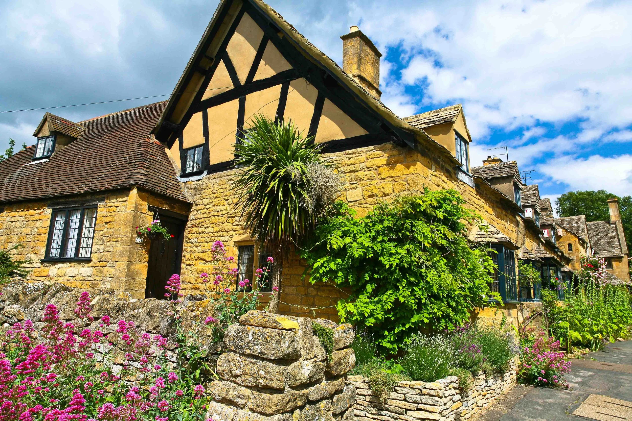
Corner house in Broadway, Cotswolds, England. As usual, the houses on this street are constructed using the golden Cotswolds stone. (2006)
Many of the towns and villages have, from the perspective of a foreigner, really quaint names such as Stow-on-the-Wold, Bourton-on-the-Water, Wotton-under-Edge, and Chipping Campden. Each of those places is at least as good a choice as Broadway for present purposes. Three things all places in the Cotswolds have in common is green rolling hills with pockets of forests, the golden Cotswold stone used in constructing buildings, and time seems to have stopped. In addition, many inhabitants seem to be fond of flowers, and some people still use thatch for their roofs although I understand that is an expensive choice anymore. Although not universal, hedges line roads as they do in many places in Great Britain.